
prettymaps

This was part of a blog post that was started but never finished. I'm not sure what I was getting on about but this is a nice picture so I've left it. (2013)
This blog post is full of links.
#prettymapsFlickr Shapetiles

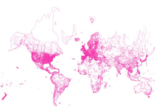
A while back, Seth took the Flickr Shapefiles XML dump, cleaned it up (sorry about that everyone...) and saved it all as an actual, well... ESRI shapefile. Despite my best efforts, and badgering, I've never been able to get him to finish writing a blog post about how he did that so I eventually settled for just getting a copy of the shapefile(s) for my own amusement.
I got to thinking about it again, last week, after I needed to test some geo-related code with a bunch of (not dots). I remembered that Mike had imported all the Flickr Shapefiles in to a PostGIS database but when I looked at the schema I noticed that all the WOE IDs had been imported without any of their associated place types.
Just for kicks, I decided not to worry about that and render all the intersecting shapes for a given bounding box. I thought it would be funny to try because I am a bit childish that way. It turned out to be lovely and fascinating. So much so that I decided I wanted to make it in to a real and proper tileset for slippy maps and other projects like Untitled Intimacies.
Over the weekend I grabbed the shapefiles that Seth had made, stuck them in PostGIS and learned just enough Mapnik (thanks Dane!) to nearly kill the little virtual machine I have running in the cloud castles; enough to render zooms levels 1 through 10.
Here it is, then, a full-screen slippy map that you can pan around and double-click to zoom in (and shift double-click to zoom out):
There's an about page on the map site itself so I won't bother repeating all the details here, other than to say there's been a JavaScript port of ModestMaps hiding in plain sight for a little while now and it's awesome. Woosh!
This blog post is full of links.
#shapetiles